Farragut "Virtual" Tunnel (Farragut Crossing) Now Operational

I don't know if I should claim any credit for this finally happening, but I have been fairly vocal about it for a long time on several forums.  Finally on Saturday, October 29, 2011, the "Farragut Crossing" virtual/invisible tunnel transfer option began between Farragut North and Farragut West stations.


Here's the first line from my original post below:
"I can't take credit for this idea--I read it somewhere else--but it's so good that it needs to be promoted and publicized until Metro takes notice and implements it."
That was August 30, 2008, 38 months ago.  I'm glad to see it finally happened, but it's a bit discouraging to see that a no-brainer idea like this one can take so long.  Imagine how long something expensive or contentious would take.

For history buffs, here's a comprehensive listing of all my posts and some other relevant links.

Kids keep getting smarter. More and more bicycling to school.

Twice in the past (here and here) I reported on the bikes that were parked in the racks at Swanson Middle School in Arlington.  Two years ago there were thirteen.  Last year there were eighteen, and they had expanded the racks.  This year on bike-to-school day there were twenty-one, and as you can see in the photos below, they are just about out of room in the bike racks again.  One rider's bike is parked on a nearby tree.
It's great to see more and more school kids riding bikes to school (and some staff, too).  There are about 800 students and staff at Swanson, so these bikes represent 2-3% of the total population.
Swanson bikes 2011 btsd
Bike racks are full on bike to school day 2011

Swanson bikes 2011 btsd 2
One cyclist's bike is parked on the tree due to full racks
\

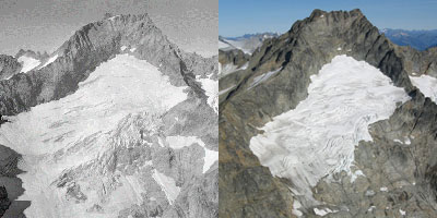
State of Folly 5 - How Crichton is wrong about glaciers

This is the fifth in a series of posts related to Michael Crichton's State of Fear, which I just read this summer. [previous posts here and here and here and here]

From page 530, a conversation between Kenner and Ted Bradley:


"How many glaciers are there in the world, Ted?"
"I don't know."               "Guess."
"Maybe, uh, two hundred."

Who owns the signs? And why won't they take them down?

I've noted a couple of signs in Northern Virginia that indicate the way to Dulles Airport.  One is on Route 50 in Arlington just past the Courthouse exit at the 10th St. exit.  The other is on Little River Turnpike between Braddock Road and Old Columbia Pike.

View Dulles Airport signs in a larger map

Here's what they look like:  
Dulles airport sign route 50 close up
This is the sign on Route 50 in Arlington.

Dulles airport sign on Route 50
Here's its location.  You can see the 10th St. exit sign that is in the median.

Dulles airport sign on Little River
Here's the one on Little River Turnpike.

The existence of these signs raises a number of questions:
  • Who owns them?
  • How long have they been there?
  • Why are they still there?
  • What purpose do they serve?
    I suspect these signs date from before I-66 was built, since no one would take Route 50 to get to Dulles with I-66 available.  Also, neither of these--as far as I have noticed--has any follow on signs, so a traveler who noted the sign would never see another one to guide them on their way.  A single directional sign far from its destination without any more to assist the traveler is probably worse than no sign at all.

    There may be more of these Dulles airport signs.  Have you seen any?  Where?

    Taking a macro view, who is responsible for signage in general?  Once a sign is placed is it ever taken down?  I've seen signs in my neighborhood that have rusted so badly they can barely be read and that are completely outdated.  Signs like these are everywhere, and they just accumulate.

    Perhaps every sign should have information on the back of it that tells who owns the sign and who is responsible for it, as well as contact information.  At least that way someone could try to follow up and notify the owner if it gets damaged or becomes obsolete.
    ======================
    Steve Offutt, Arlington

    State of Folly 4 - How Michael Crichton was wrong: 1970s Global Cooling

    This is the fourth in a series of posts related to Michael Crichton's State of Fear, which I just read this summer. [previous posts here and here and here]

    On page 394, the "arch-villain" Henley (in the plot, he is the key character behind the efforts to manufacture big climate events) says:

    Solving the Lynn Street/Lee Highway Bike/Car Conflict

    The intersection of Lee Highway and Lynn Street in Rosslyn, where the Custis Trail crosses Lynn St., has been the subject of great scrutiny lately. (GGW reported on a recent meeting at this very intersection.)  This is one of the most dangerous intersections for cyclists in the Greater Washington area. By reconfiguring the exit ramp for the Key Bridge, this conflict can be entirely removed, dramatically improving safety while also potentially improving traffic flow.  (This post has been cross-posted at Greater Greater Washington, including a number of reader comments.)

    The problem at this intersection is traffic turning right from the I-66 off-ramp onto Lynn Street traveling towards the Key Bridge.  This traffic has a green light at the same time as the pedestrians and cyclists have the cross signal. There are two lanes of right turning cars (and sometimes cars in the third lane turn right illegally). By shifting the Key Bridge traffic to the north of the Custis Trail crossing, this conflict will be eliminated.

    Upcoming Event: Transforming energy performance in Houses of Worship

    The Environment Group of the National Capital Presbytery is sponsoring/presenting a key session open to all churches and other houses of worship interested in saving $ from their annual operating expenses.

    Presentation and Q&A session on: Updating your energy system to the 21st century & reducing your carbon footprint: how to do it for free (or almost).

    Date: Saturday, October 22
    Time: 10 am to noon
    Location: Warner Memorial Presbyterian Church
        10123 Connecticut Avenue, Kensington, MD (map)
    This is a free presentation.
    Click here to RSVP

    It's already here. Not far in the future. Climate affecting politics and disaster relief, that is.

    The most recent political skirmish in DC was over $1.6 billion in disaster relief funding. The GOP was working to turn this into a political negotiating tool to extract other concessions. It didn't end up making much difference, and the political blogosphere saw it as more examples of dysfunctional government.

    I, however, see it as not only that, but also a canary-in-the-coal-mine moment. As the future of climate change bears down on us faster than anyone was expecting, disasters like this year's (9 $1-billion+ disasters already this year) are going to require more and more emergency funding. Eventually these disasters are going to require much bigger political decisions than what we see now. Remember, Nicolas Stern predicted that climate change could take up to 20% off global GDP. That's not only a huge hit on available resources, but there will also be enormous costs to actually deal with the floods, droughts, storm surges and other direct effects of warming-enhanced events.